Overall Project
How is this current phase different from previous project phases?
The current phase of the Benning Road Bridges and Transportation Improvements Project is advancing final engineering design plans for the corridor. This current phase is building upon the work produced during the previous preliminary design phase and the approval of the Benning Road and Bridges Transportation Improvements Environmental Assessment (EA) in November 2020 using new and updated field surveys, traffic analysis, and bridge conditions assessments.
The draft Benning Road and Bridges Transportation Improvements Environmental Assessment (EA) was published in April 2016, modified during the preliminary engineering phase of the Benning Road Bridges and Transportation Improvements Project in 2019 and 2020, and approved in November 2020. DDOT, in conjunction with the Federal Highway Administration (FHWA), and in cooperation with the Federal Transit Administration (FTA), National Capital Planning Commission (NCPC), and National Park Service (NPS), has released the Final Environmental Assessment (EA) and the Finding of No Significant Impact (FONSI) for the Benning Road and Bridges Transportation Improvements Project.
The final EA evaluates transportation improvements and their potential impacts in accordance with the National Environmental Policy Act of 1969 (NEPA), the Council of Environmental Quality (CEQ) regulations (40 CFR 1500-1508), and the Federal Highway Administration’s (FHWA’s) Environmental Impact and Related Procedures (23 CFR 771).
In coordination with the completed preliminary design phase, DDOT has studied interchange modifications at DC-295 and Benning Road NE. The Preferred Alternative design can be reviewed here. Once completed, the final Interchange Modification Report will be posted to the project website.
How much will the project cost?
During the project’s preliminary engineering phase, a preliminary project cost estimate of $178.1 million was prepared. The project construction cost is under refinement as a part of the final design phase and will be provided once finalized.
What are the property impacts of this project?
The majority of the project will be built within DDOT right-of-way. Some Washington Metropolitan Area Transit Authority (WMATA) right-of-way has been identified for the end-of-line at the Benning Road Metrorail station and a traction power substation (TPSS) facility located near the Benning Road Metrorail station. The project will not displace or relocate any residence, business, or community facility; however, the geometry of the road will change and will bring the curb on each side of the street closer to adjacent residences and businesses in some locations.
The planned roadway geometry changes will result in the need to remove street trees. Mitigations are being considered to replace the removed street trees. The final extent of tree removal will be determined in the design process, following a detailed survey of the corridor’s street trees. DDOT’s Urban Forestry Administration will develop and implement a street tree management plan. The street trees would not be removed as a result of the propulsion (power) system for the planned streetcar extension.
While final design efforts are still under refinement, work conducted since the preliminary (30%) design phase has identified a need for the following property impacts:
- Temporary Construction Easement: Temporary right to perform construction activities on the property of another party granted by easement, license or permit, this easement automatically expires at the end of the project construction period
- Perpetual Easement: Instances where property owner will retain underlying fee simple interest but the District/DDOT will obtain an easement in perpetuity for the construction, maintenance and use of the specific area for a specific purpose
- Fee Simple: DDOT will obtain fee simple interest and title to property based on project needs
- Curb Cut Modifications and/or Closures: Instances where property access (curb cuts) will be adjusted, reduced, relocated, or closed as a result of design standards and safety mitigations may result in fee simple acquisitions.
In advance of construction, DDOT will examine public records to identify all applicable impacted property owners and DDOT staff and/or consultants will contact those owners to discuss the right of way acquisition process.
How is Public Space Defined?
Public space is a broad term that includes that area within the street right-of-way and can take on many different appearances. Typically thought of as the publicly owned area between private property lines, it includes the roadway, tree space, sidewalk, and often what appears to be front yards.
When will construction start? When will the project be completed?
The preliminary design phase concluded in Fall 2020 and the final design phase is expected to conclude in Spring/Summer 2022. Construction Is anticipated to start in Winter 2022 and project construction completion is anticipated in 2025-2026. Changes to funding availability, utility relocation impacts, and decisions made during final design could affect this schedule.
Will there be any road closures during construction?
As part of the construction phase, travel lanes will be temporarily closed in sections of the corridor for the construction of streetcar tracks, interchange modifications, and reconstruction or rehabilitation of the bridges. A maintenance of traffic (MOT) plan has been developed that details lane closures and any detour routes for all travel modes (pedestrians, bicyclists, buses, and automobiles). DDOT anticipates using Accelerated Bridge Construction (ABC) methods to reduce the duration of construction. Constructing roadway and bridge improvements together with streetcar elements also will reduce impacts to the community over the long term.
Will the project lead to new development?
The District identified the Benning Road corridor as an area for commercial and residential redevelopment via its designation as a Great Street. The Great Street program allows existing small businesses and new businesses to apply for up to $85,000 in reimbursable grants for capital expenditures. Redevelopment already is occurring along the corridor and will likely continue due to its proximity to employment centers and the Metrorail system. Introducing an additional transit option would support the existing and future development by increasing safety, mobility, and connectivity in the corridor.
How does this project fit with the Anacostia Waterfront Initiative (AWI)?
Initiated in 2000, the AWI envisions a clean river environment, new parks and other recreational facilities, more job-creating commercial centers, revitalized residential neighborhoods, and multimodal transportation options through DDOT infrastructure projects. Improvements to and the reconstruction of the Benning Road/DC-295 interchange are proposed in the 2014 Anacostia Waterfront Initiative Transportation Master Plan.
What is NEPA? What is IMR?
Congress passed NEPA in 1969. The act promotes better-informed decision making as a part of federally funded projects. NEPA requires preparation of an environmental document to evaluate the environmental effects of federally funded projects, and requires transportation agencies across the country to clearly state why a project is needed (“Purpose and Need Statement”), provide adequate consideration of feasible alternatives, and pursue the development of mitigation measures to ensure that potential negative impacts from the planned project are avoided, minimized, or mitigated to the greatest degree possible. The environmental document for the planned Benning Road Bridges and Transportation Improvements Project is an Environmental Assessment (EA). The final EA evaluated several “Build” alternatives as well as a “No Build” alternative. Reviewing agencies have determined that the Build alternative will not result in significant environmental impacts, and the District is now moving the Benning Road Bridges and Transportation Improvements Project forward through subsequent final design and construction phases.
An interchange modification report (IMR) is required when new or revised vehicular access to the highway system is proposed. A decision to approve such modifications must be supported by considerations and requirements related to operations, safety, and access. DDOT is studying interchange modifications at the DC-295/Benning Road ramps through an IMR and a separate NEPA study for the interchange. With approval of the access modification and an environmental determinization that the modification would not result in significant environmental impacts, the District could move the DC-295/Benning Road ramps project forward through subsequent final design and construction phases.
The Preferred Alternative design can be reviewed here and the final Interchange Modification Report will be posted to the project website.
H/Benning Streetcar
What will happen to bus service that runs along the corridor today?
Bus service that runs along the corridor today is operated by WMATA as Metrobus service. No changes to existing Metrobus routes are expected as a result of this project; however, local Metrobus stops may need to be relocated to accommodate the streetcar stop platform at the Benning Road Metrorail station.
Why streetcar service instead of bus service?
Metrobus passenger surveys indicate that crowding and schedule adherence along the H Street and Benning Road corridor are key issues. Streetcar vehicles provide many benefits, including:
- The ability to accommodate up to 150 people seated and standing (as opposed to 48 on a regular Metrobus and 65 on an articulated Metrobus)
- All-door boarding, allowing passengers to board and alight using three doors simultaneously on the streetcar
- Fewer stops and more streamlined routing, reducing delays that buses experience from stopping more frequently to pick up and drop off passengers every block
These advantages make the streetcar more attractive than buses, particularly when passengers are riding between the Benning Road Metrorail station and Union Station. The extension of streetcar service will also help shift passengers from Metrobuses to the streetcar, thereby reducing crowding and bus bunching along the corridor.
Will the streetcar extension be median-running or curb-running?
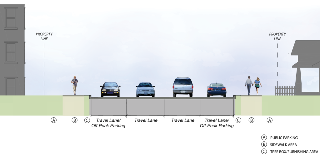
The existing H/Benning line features both median- and curb-running tracks. As part of the ongoing Benning Road and Bridges Transportation Improvements Project EA, DDOT selected a median-running streetcar for the entirety of the eastward extension from Oklahoma Avenue NE to the Benning Road Metrorail station. A median-running streetcar extension would feature median streetcar stops and allow for continued off-peak parking along portions of Benning Road.
What will be the locations of the new streetcar stops? How were these locations decided?
Six new streetcar stops are planned to be located along Benning Road NE:
- Oklahoma Avenue NE
- Kingman Island
- 34th Street NE
- 39th Street NE
- 42nd Street NE
- Benning Road Metrorail station
These locations have been determined based on spacing, proximity to key local destinations, and physical opportunities and limitations.
What is the planned propulsion (power) technology for the Benning Road streetcar extension?
DDOT is planning to use on-wire propulsion technology for the Benning Road streetcar extension as part of the Preferred Alternative. Under wired operation, new streetcars would contain the same electrical components as the existing vehicles and would receive electric power from an overhead wire via a roof-mounted pantograph. The selection of on-wire propulsion does not preclude the option of new technologies being used on the corridor at a later date.
Will the streetcar have separate traffic signals?
In locations where the streetcar must cross active lanes of vehicular traffic, additional streetcar-only signals would be needed. The need for streetcar-only signals will be determined as part of the ongoing preliminary design process.
Why will the streetcar extension go to the Benning Road Metrorail station and not the Minnesota Avenue Metrorail station?
Following a screening process within the ongoing EA, streetcar extension concepts to the Minnesota Avenue Metrorail station were eliminated from consideration. Extending the streetcar to the Benning Road Metrorail station provides an important connection between the streetcar and Metrorail in the study area, results in higher ridership, and allows for more direct trips in the corridor.
Based on ridership forecasts prepared for the project, the Benning Road streetcar extension is projected to have approximately 550 daily riders for the Minnesota Avenue terminus option and 3,500 daily riders for the Benning Road terminus option. During the alternatives development process, the Benning Road terminus option performed the best against the 20 screening factors.
The Minnesota Avenue terminus option was not carried forward for detailed study due to geometric deficiencies in the preliminary screening process (streetcars making the turn from Benning to Minnesota had substantial impact on the intersection). Physical and geometric constraints of the Benning Road and Minnesota Avenue intersection would complicate streetcar track and roadway construction. Additionally, accommodation of a track and platform near the intersection could negatively affect overall traffic operations or create new safety issues for pedestrians. For more information, please reference Chapter 2 – Alternatives of the draft EA here: www.benningproject.com/resources/
How often will the streetcar run? What will be the hours of operation of the streetcar?
DC Streetcar’s normal hours of operation are:
Monday–Thursday: 6:00 a.m. – midnight
Friday: 6:00 a.m. – 2:00 a.m.
Saturday: 8:00 a.m. – 2:00 a.m.
Sunday and Holidays: 8:00 a.m. – 10:00 p.m.
DC Streetcar currently has 10- to 15-minute headways, meaning passengers’ waiting time at a stop should be no more than 15 minutes. . Existing service will be extended and will operate at the same or slightly higher frequency (10- to 12-minute headways).
How much will it cost to ride the streetcar?
DC Streetcar is currently free to ride. DC Streetcar will remain free to residents and visitors of the corridor until DDOT conducts a fare analysis. Should DDOT decide to make a change in fare policy, a public announcement will be made.
What happens if the streetcar breaks down?
In the case of a streetcar accident or breakdown, the streetcar will be towed back to the maintenance area with a specialized vehicle. In the case of a car accident, emergency response teams will move the car away from the streetcar as soon as possible. DDOT is committed to providing connectivity with existing transit services and will work with regional partners should an event occur. On the existing line, most of the delays have not been caused by streetcar vehicles breaking down but by other incidents such as traffic crashes, bus breakdowns, or emergency responders.
Bicycle and Pedestrian
How will bicycle safety be improved as part of this project?
Dedicated off-street bicycle facilities are planned between Oklahoma Avenue and Blaine Street NE. These planned bicycle facilities will alternate between shared-use paths (for both bicycles and pedestrians) and a cycle track (dedicated space for cyclists separate from the sidewalk):
- Oklahoma Avenue NE to Kingman Island: Shared-Use Path
- Kingman Island to 34th Street NE: Cycle Track
- 34th Street NE to Blaine Street NE: Shared-Use Path
How will pedestrian conditions be improved in the project area?
The reconstruction of sidewalks along Benning Road will improve pedestrian conditions in the corridor. Additionally, the Benning Road and DC-295 interchange modifications will enhance safety and access for pedestrians where Benning Road interfaces with the highway’s on- and off-ramps. The reconstruction of the Lorraine H. Whitlock Bridge over DC-295 and the CSX freight rail tracks also will provide sidewalks on both the north and south sides, allowing pedestrian movement on both sides of the bridge. Additional planned improvements to the pedestrian network include:
- A new pedestrian crossing with a traffic signal at the Kingman Island streetcar platform
- New pedestrian crossings with a traffic signal for new ramp connections at the Benning Road and DC-295 interchange
- Enhanced, high-visibility crosswalks at all Benning Road intersections and future streetcar stops
- Sidewalks between 42nd Street NE and the Benning Road Metrorail station that currently do not meet Americans with Disabilities Act (ADA) specifications would be brought up to ADA standards
Bridges
Are bridges being replaced and rehabilitated as part of the project?
Bridge condition assessments have been conducted as part of the design project.
- The Benning Road Bridge, traveling over Kingman Lake, will be rehabilitated if the project moves forward.
- The Ethel Kennedy Bridge, carrying Benning Road across the Anacostia River, will be rehabilitated if the project moves forward.
- The Lorraine H. Whitlock Bridge, carrying Benning Road over DC-295 and the CSX freight rail tracks, is comprised of two separate eastbound and westbound structures. These structures do not meet the minimum requirements for height above the rail tracks or current design standards to provide safe passage for pedestrians and bicyclists. The condition of the existing structures and the planned roadway modifications—including pedestrian and bicycle facilities— results in the need to fully replace the two aging structures if the project moves forward.
Can we have the interchange modification project and bridge replacements without the streetcar?
The interchange modification project and bridge replacements have been integrated into the overall funding mechanism and multimodal improvement project, which has been approved to proceed with the inclusion of an extension of streetcar service. Funding the interchange modification and bridge replacements in isolation would result in the loss of all the other planned corridor improvements along Benning Road.
DC-295 and Benning Road Interchange
How will the interchange design mitigate U-turn movements at 34th Street NE?
The majority of the U-turns today are a result of trips heading westbound on Benning Road NE to DC-295 or those traveling northbound on DC-295 that wish to go east on Benning Road NE. The reconfigured and new northbound DC-295 ramps will aid in reducing U-turns at 34th Street. While removing the southbound Kenilworth to northbound DC-295 movement could create a U-turn condition for a few vehicles, the traffic modeling demonstrated that most of these trips would use the Nannie Helen Burroughs Avenue interchange.
Why does the interchange design not incorporate a ramp from Kenilworth Avenue NE to eastbound Benning Road NE?
The elevation of the WMATA bridge structure in relation to Kenilworth Avenue NE is a constraint to constructing a ramp for southbound Kenilworth Avenue NE to eastbound Benning Road. In addition, there is limited space to incorporate this ramp within DDOT ROW.
Traffic
How will traffic flow be impacted by this project?
The final EA found that the operation of streetcars and transitions at most intersections would result in very little impact on vehicular delay and traffic flow. The current preliminary design process will include more detailed multimodal analysis of the corridor and will seek to identify mitigations for negative traffic impacts. Temporary traffic impacts would be expected during potential future construction activities should the project advance, for which DDOT would develop a transportation management plan.
Will the streetcar run in mixed traffic or will it have its own lanes?
Similar to the existing H/Benning streetcar line, the planned Benning Road extension would have streetcar operations occurring in shared lanes with mixed traffic. The streetcar will operate with traffic in one of the current lanes of Benning Road in each direction of travel. Sharing a travel lane enables DDOT to provide the planned improvements (roadway, bridge, streetcar, bus, bicycle, and pedestrian) within the existing Benning Road right-of-way.
During the alternatives development process, exclusive streetcar lane concepts were explored but ultimately were not carried forward because the elimination of a general purpose travel lane would result in new impacts, such as delays and longer travel times for buses and other vehicles.
Public Engagement
How does this project incorporate feedback the community has previously shared with DDOT?
Community needs, preferences, and input voiced during past studies—including the DC Transit Future System Plan, DDOT Benning Road Streetcar Extension Study, and Benning Road Corridor Redevelopment Framework Plan and EA—will help shape and inform the project to improve access, operations, and safety for all users along the Benning Road corridor.
How do I participate?
DDOT invites you to subscribe to project updates and to attend upcoming meetings. Please visit the Get Involved! page to subscribe and view upcoming public meeting information.
How can I request a project briefing for my organization or submit comments on the project?
To request a project briefing for your organization, please send an email to info@benningproject.com or to DDOT Project Manager Emnete Banko at emnete.banko@dc.gov.
To submit comments on the project, please click here to use the comment form.
How will community feedback be used in the preliminary design process?
DDOT will seek community feedback on several aspects of the project, including bridge aesthetics, streetcar stop design, trail connections, streetscape design, and bicycle and pedestrian facilities. This feedback will be used to inform the preliminary design.
Coordinated Projects and Studies
What other DDOT work is occurring in the project area? How will they be integrated with this project?
Several other DDOT projects and studies have occurred in the project area, including the Minnesota Avenue Revitalization project, Parkside Access Study, the East Capitol Street Safety and Mobility Project, and improvements to safety and mobility throughout the I-295/DC-295 corridor. DDOT will design the Benning Road Bridges and Transportation Improvements Project to be compatible with recently completed and ongoing projects near and along Benning Road NE.
DDOT will continue working to ensure that the project is coordinated with all planned and future developments along the Benning Road NE corridor.